


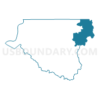
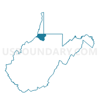
Voting District 10, Wetzel County, West Virginia
About
Outline

Summary
| Unique Area Identifier | 692038 |
| Name | Voting District 10 |
| County | Wetzel County |
| State | West Virginia |
| Area (square miles) | 36.30 |
| Land Area (square miles) | 36.30 |
| Water Area (square miles) | 0.00 |
| % of Land Area | 99.99 |
| % of Water Area | 0.01 |
| Latitude of the Internal Point | 39.65435990 |
| Longtitude of the Internal Point | -80.45431120 |
Maps

Graphs
Select a template below for downloading or customizing gragh for Voting District 10, Wetzel County, West Virginia


Neighbors
Neighoring Voting District (by Name) Neighboring Voting District on the Map
- Voting District 27, Wetzel County, WV
- Voting District 4, Wetzel County, WV
- Voting District 42, Monongalia County, WV
- Voting District 5, Wetzel County, WV
- Voting District 74, Marion County, WV
- FREEPORT TWP Voting District, Greene County, PA
- SPRINGHILL TWP Voting District, Greene County, PA
Top 10 Neighboring County Subdivision (by Population) Neighboring County Subdivision on the Map
- Western district, Monongalia County, WV (27,045)
- West Augusta district, Marion County, WV (17,224)
- District 1, Wetzel County, WV (5,800)
- District 2, Wetzel County, WV (5,417)
- Springhill township, Greene County, PA (349)
- Freeport township, Greene County, PA (310)
Top 10 Neighboring Place (by Population) Neighboring Place on the Map
Top 10 Neighboring Unified School District (by Population) Neighboring Unified School District on the Map
- Monongalia School District, WV (96,189)
- Marion County School District, WV (56,418)
- Wetzel County School District, WV (16,583)
- West Greene School District, PA (5,108)
Top 10 Neighboring State Legislative District Lower Chamber (by Population) Neighboring State Legislative District Lower Chamber on the Map
- State House District 50, PA (59,028)
- State House District 43, WV (56,711)
- State House District 5, WV (16,663)
Top 10 Neighboring State Legislative District Upper Chamber (by Population) Neighboring State Legislative District Upper Chamber on the Map
Top 10 Neighboring 111th Congressional District (by Population) Neighboring 111th Congressional District on the Map
Top 10 Neighboring Census Tract (by Population) Neighboring Census Tract on the Map
- Census Tract 9704, Greene County, PA (4,290)
- Census Tract 305, Wetzel County, WV (4,215)
- Census Tract 114, Monongalia County, WV (3,829)
- Census Tract 218, Marion County, WV (3,053)
- Census Tract 304, Wetzel County, WV (3,045)
Top 10 Neighboring 5-Digit ZIP Code Tabulation Area (by Population) Neighboring 5-Digit ZIP Code Tabulation Area on the Map
- 26582, WV (5,335)
- 26581, WV (1,104)
- 15352, PA (987)
- 26575, WV (827)
- 26437, WV (645)
- 26562, WV (634)
- 26585, WV (479)